
 Active
1 / 31


 Listing courtesy of Congress Realty, 888-881-4118
21st SW at Franklin AVE
Bandon, OR 97411 · Coos County
RMLS # 413618349
About this home
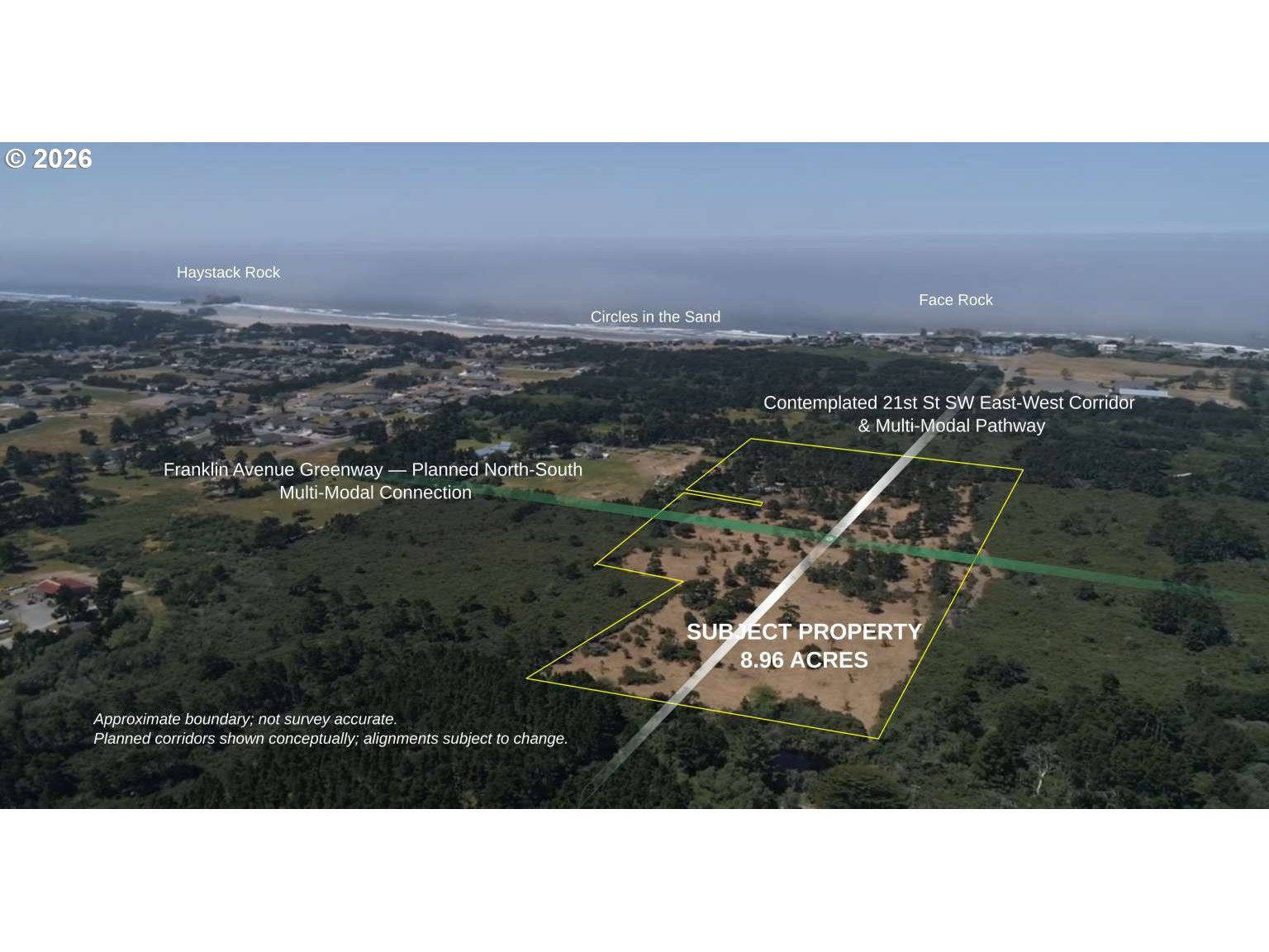
Address: 21st St SW at Franklin Ave, Bandon, OR 97411. 8.96 Acres in Bandon UGB — Planned Crossroads: Hwy 101-to-Beach Corridor & North-South Franklin Greenway Face Rock Heights offers 8.96 contiguous acres west of Hwy 101 inside Bandon's Urban Growth Boundary. Level and substantially cleared, with open ground and mature shore pines throughout and greater tree cover to the west. Five tax parcels under common ownership encompass 154 previously platted residential lots. Parcel IDs: 28S-1536AD 03301, 28S-1536AC 02300, 28S-1536AC 03100, 28S-1536AC 02200, 28S-1536AC 02101. Zoned Coos County UR-2; future annexation and rezoning require approvals. Existing highway access is a major advantage: County-permitted 21st St SW is a 20-ft-wide, two-way gravel road from Hwy 101 at Mile Marker 275, extending roughly 200 ft into the property area. The site lies at the planned crossroads of east-west 21st St SW toward Face Rock Road and Beach Loop, and the north-south Franklin Avenue Greenway. In March 2026, Gravel Point outlined plans to use 21st St SW for construction access, with later upgrades to City standards. Corridor plans envision city water, sewer, related utilities and a pedestrian/bicycle pathway. Timing and work remain subject to approvals. Existing improvements include a homestead with a 1996 Fleetwood manufactured home offered as-is, gravel driveway with large-vehicle hammerhead turnaround, well, septic, underground electric service, cable and six shipping containers. Primary value lies in the land, location and long-term connectivity potential. Face Rock State Scenic Viewpoint and beach access are nearby. If the planned connection is completed, a 21st St SW route could offer an approximately one-half-mile beach walk. Adjacent 5.22 acres offered separately could allow a 14.18-acre assemblage, subject to availability. Buyers should verify access status, uses, boundaries, utilities, costs and feasibility. Sources: City of Bandon 2025 TSP; The World, Mar. 17, 2026.
Details
Overview
- RMLS #
- 413618349
- Status
- Active
- County
- Coos
- Taxes
- $1,980 a year
Lot
- Lot Features
- Cleared,Corner Lot,Cul-de-sac,Pasture,Public Road,Trees
- Lot Size Dimensions
- Approx. 1,118 x 480
- Zoning
- UR-2
Parking
- Attached Garage
- No
Location
21st SW at Franklin AVE, Bandon, OR 97411 · Coos County
Drag to move around. Use + and − to zoom. Open in Google Maps ↗
Nearby Schools
Assigned schools as listed by the seller's agent. Confirm school boundaries with the school district.
Flood and Hazard Risk
Flood zone from FEMA's National Flood Hazard Layer for this location. Hazard ratings are for the surrounding census tract from the FEMA National Risk Index. View the FEMA flood map ›
Price and Tax History
Price history
Property taxes
Estimated Monthly Payment
Similar homes nearby
-
 Active
$2,395,000
0 bd · ba
00 1807 Agate LN, Bandon, OR 97411
Listing courtesy of Pacific Coast Real Estate & Development, LLC, 541-808-3297 -
 Active
$1,800,000
3 bd · 2 ba · 2,234 sq ft
1575 BEACH LOOP DR, Bandon, OR 97411
Listing courtesy of David L. Davis Real Estate, 541-347-9444 -
 Active
$1,800,000
4 bd · 3 ba · 4,097 sq ft
865 SW PORTLAND AVE, Bandon, OR 97411
Listing courtesy of Pacific Properties, 541-347-5263